Getting to the Pass Creek Yurt
Pass Creek Yurt
Elevation – 10,250 feet
Summer trailhead parking: 33 miles/1.5 hour drive NE of Pagosa Springs, CO. 18 miles/1 hour drive SW of South Fork, CO.
Winter trailhead parking is at Wolf Creek Ski Area: 28 miles/1 hour from Pagosa. 20 miles/30 min from South Fork, CO.
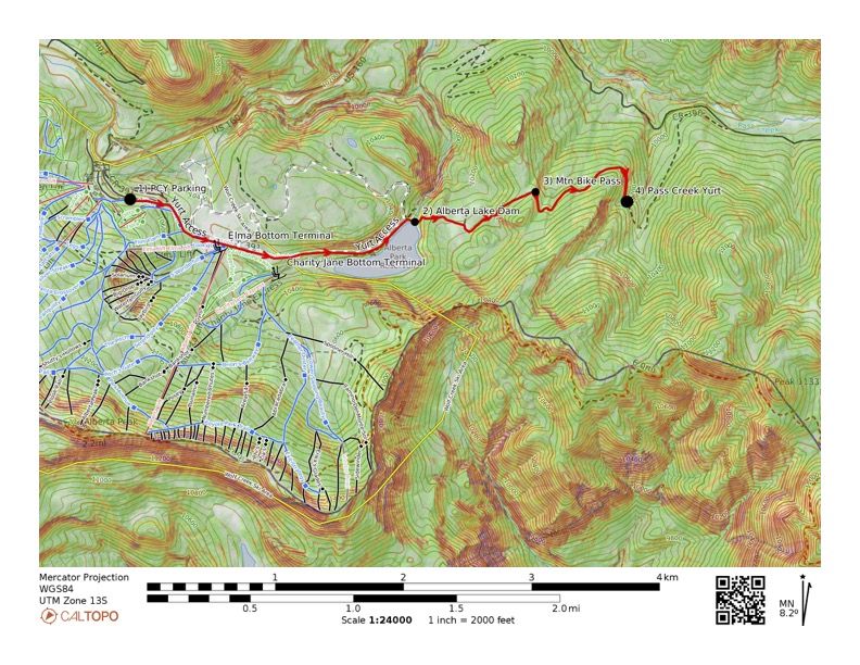
Winter Access Directions
Parking: Download, print and complete this OVERNIGHT PARKING PASS. Be sure to place a PARKING PASS with the correct dates on the dashboard of each vehicle. Please bring as few vehicles as possible. Park in the Wolf Creek Ski Area Alberta Lot. Park ONLY in spaces designated “YURT PARKING”. If you can’t locate it, you MUST contact a parking staff to help you. They will direct you to the assigned parking.
Click here to download the PARKING PASS
Distance from Parking Lot to PCY: 3 miles
Elevation gain 400’, Elevation loss 800’
Time: Expect the approach to take 2-4 hours; longer with trail breaking. Plan appropriately to arrive before dark.
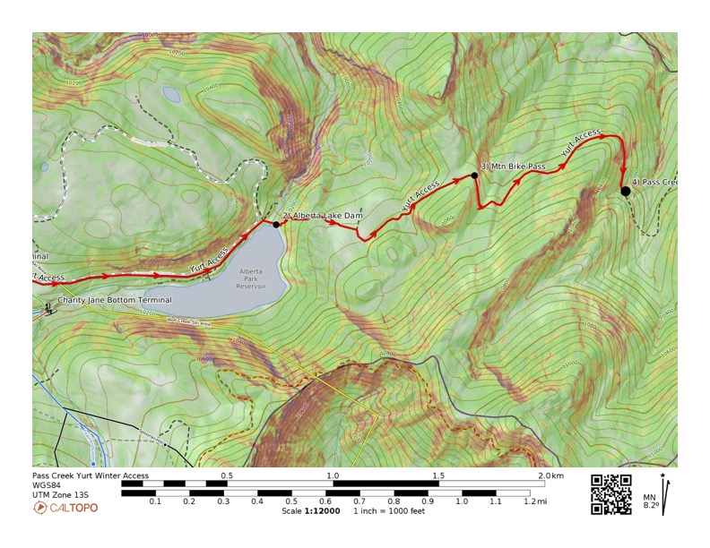
Directions: Descend the groomed ski trail toward the base of the Alberta Lift. Pass to the left of the Alberta Lift and look for the brown USFS “Alberta Reservoir/Pass Creek Yurt” sign 100 yards past the Alberta Lift. Follow the cross-country trail / Alberta Reservoir road (sometimes groomed) downhill to Alberta Park Reservoir dam. Cross the dam & climb a short, steep hill to your left, and to the right of the creek. Travel .5 mile through woods, then gain an old logging road to a small pass just north of point 10,615’ (Mtn Bike Pass). From here it is a gentle 1 mile downhill run contouring on an old logging road to the Pass Creek Yurt. If the weather is inclement and/or there is not a track to follow, map and compass and/or GPS navigation may be necessary.
Note: Pink and silver survey flagging marks the route from the Alberta Lake dam to the Yurt (in early season look high in the trees). Although we make an effort to maintain the tape, we don’t guarantee its presence. Do not depend on it to get you to the Pass Creek Yurt. Download the Winter PCY map below to help you navigate, and write down and bring along the GPS coordinates below.
Winter Coordinates for Pass Creek Yurt:
|
WC Ski Area Pkg Lot: |
|
|
Alberta Lake Dam: |
|
|
Mtn Bike Pass: |
|
|
Pass Creek Yurt: |
The USGS 7.5’ quads for the area are “Elwood Pass” and “Wolf Creek Pass”.
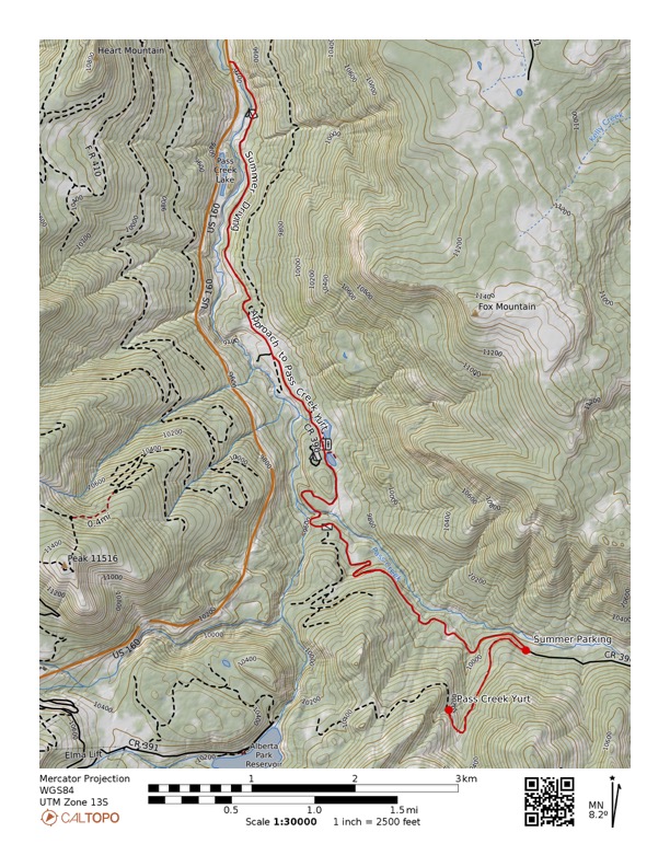
Summer Access Directions
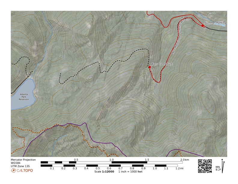
Drive to Trailhead: Turn south from Highway 160 onto the Pass Creek/Tucker Ponds Road/FS RD 390*. Drive 5.8 miles on this 2-wheel-drive gravel road. At 5.8 miles look for a large turnout on the left. Park here. Look for the locked, rusty green Forest Service gate uphill of the parking area. You can also park by the gate as long as you don’t block the gate.
Distance from Parking location to PCY: 1 mile. Elevation gain 200′
Time: Expect the approach to take 1 hour. Plan appropriately to arrive before dark.
Directions: The elevation gain is minimal (200′) and gradual with the steepest bit just before you reach the Pass Creek Yurt. Stay on the obvious, best logging road; do not make any turns off this road. When you see the old yellow truck you are almost there.
Do not leave valuables in your car.
Summer Coordinates for Pass Creek Yurt:
|
Jct 160 – FSR 390 |
|
|
PCY Parking |
|
|
Pass Creek Yurt |
The USGS 7.5’ quads for the area are “Elwood Pass” and “Wolf Creek Pass”.
Downloads
ADDITIONAL MAPS FOR DOWNLOAD OR MOBILE DEVICE REFERENCE
Winter Access Ski Route with slope shading
Overview Map
Detail Map of Skin Track
- https://wolfcreekbackcountry.com/pcy-winter-access-map
- https://wolfcreekbackcountry.com/pcy-winter-ski-in-map-detail
Copy these URLs to import these maps into your Avenza mobile app, or download the GeoPDFs and use in whatever way you like.
Summer Access Driving and Hiking Route
Overview Map w/ Driving
Detail of Hike/Bike Route
- https://wolfcreekbackcountry.com/pcy-summer-access-map
- https://wolfcreekbackcountry.com/pcy-summer-hike-in-map-detail
Copy these URLs to import these maps into your Avenza mobile app, or download the GeoPDFs and use in whatever way you like.